PTE Describe Image (Map) – Model Answer – PTE Academic Speaking
PTE Academic Describe (Map) – Look at the map below, study it in 25 seconds and give your answer in 40 seconds. These type of questions assesses speaking skills and requires test takers to describe images like a graph, map, chart, table or picture.
PTE Describe Image (Map) – Model Answer – PTE Academic Speaking
PTE DESCRIBE IMAGE (MAP) – MODEL ANSWER
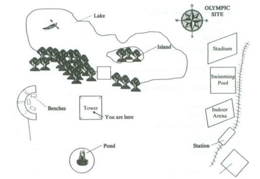
1.- Look at the map below and describe it in 40 seconds.
Well here we are at the top of the town and we gonna look at the view from each direction. Out to the east, large buildings about a kilometre away from the Olympic site, there is an indoor arena for gymnastics, swimming pool for swimming and a Stadium (track and field). If you look carefully down there, you can see the train line. The Olympic site has a station to encourage the use of public transport. If you look at the south, you can see a circle ornamental pond and around to the west, you can relax and sit on the bench to smell the flowers in the rose garden. Finally up to the north, if you look in front of you now, there is a lake with a small island in the centre and a boat at North-West.
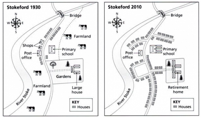
2.- Look at the map below and describe it in 40 seconds.
These two maps illustrate the development in the area of Stokeford village from 1930 to 2010. It is clearly seen that lot of changes had taken place in Stokeford village over a period of 80 years. Shops and farmland located on the River Stoke were destroyed and more houses had been constructed in 2010. River Stoke, a bridge, the post office and the primary school remained unchanged throughout the given period of time. Two houses were built next to the primary school which can be seen in 2010 map. Overall, there is a massive change in the Stokeford from 1930 to 2010 as all the farmland area was allocated to build more houses to meet expanding the population.
Don’t forget to share your own answer through comment box.


